Mount Schuyler (Bulgarian: връх Скайлър, ‘Vrah Schuyler’ \'vr&h 'skay-l&r\) is the peak rising to 1435 m off the northeast extremity of Detroit Plateau in Graham Land on the Antarctic Peninsula. Surmounting Russell West Glacier to the north and Victory Glacier to the southeast. Part of the glacial divide between Bransfield Strait and Prince Gustav Channel.
The peak is named after the American diplomat Eugene Schuyler (1840-1890) who investigated the crushing of the Bulgarian April Uprising of 1876 and co-authored the draft decisions of the subsequent 1876 Constantinople Conference.
Location
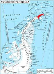
Mount Schuyler is located at 63°44′14″S 58°41′05″W, which is 2.28 km south-southwest of Sirius Knoll, 4.45 km west of Antonov Peak and 9.35 km west by north of Mount Daimler in Trakiya Heights, 12.75 km north-northwest of Mount Reece in Kondofrey Heights and 12.06 km east by south of Tinsel Dome. German-British mapping in 1996.
Maps
Trinity Peninsula. Scale 1:250000 topographic map No. 5697. Institut für Angewandte Geodäsie and British Antarctic Survey, 1996.
Antarctic Digital Database (ADD). Scale 1:250000 topographic map of Antarctica. Scientific Committee on Antarctic Research (SCAR), 1993–2016.